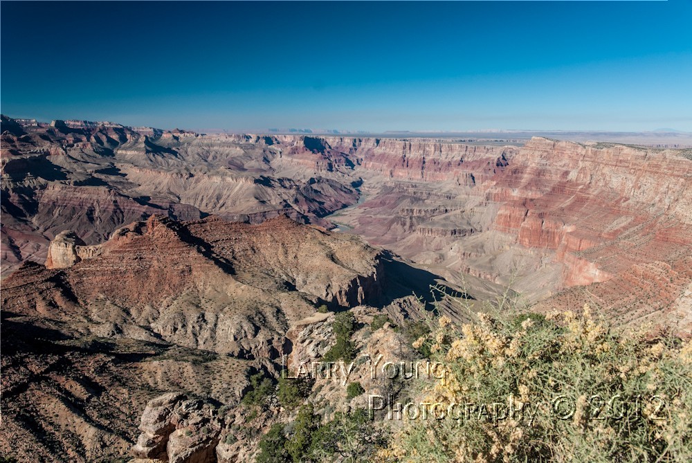
Desert View Lookout Grand Canyon

Desert View Lookout Grand Canyon

Sunday, October 21, 2012

Mary Coulter


At the age of 20 years, Mary Colter attended the California School of Design in San Francisco and eventually graduated with a degree in Architectural Design..  In 1901 Mary was hired by the Fred Harvey Company and was given the job of decorating the Alvarado Hotel in Albuquerque.  In 1910 she moved to the position of Architect.  In those days it was very unusual for a female to be hired in such an important position.  Over the next 30 years she completed 21 projects for the Fred Harvey Company.
Desertview Watchtower

Lookout Studio

Lookout Studio
Hopi House

When the Santa Fe Railroad began developing the Grand Canyon to bring tourists, the Fred Harvey Company was hired to build and design many of the buildings you see now at the Grand Canyon.  Mary was assigned the task.  She designed the Hopi House in 1905, Hermit’s Rest in 1914, the Lookout Studio in 1914, the Desert View Watchtower in 1932, and the Bright Angel Lodge in 1932.  Those four buildings as a group were listed as a National Historic Landmark in 1987.
Desertview Watchtower

During those times when she was designing the building for the Grand Canyon most the architectural designs were being crafted with a European look.  Mary wanted here buildings to complement their surroundings and look as if they had been there all the time.  If you look at her work in the Grand Canyon, you do get that impression that they had been there forever.  The Lookout Studio looks like its part of the canyon.  Hermit’s Rest is a peaceful place that time has forgotten.  Hopi House looks as if it were built by the original Anasazi people centuries ago.  The Desert Watchtower is a magnificent piece of architecture.  Mary was very fastidious about the building of her creations.  She hands-on personally directed the placement of almost every stone.  When the Desert Watchtower was being built, she took a vacation for a couple of weeks.  Before she left, she gave very precise instructions to the builders as to where each stone was to be placed.  When she returned, there was one stone out of place near the bottom of a wall.  She insisted that the wall be torn down and done correctly.


Wednesday, October 17, 2012

Wupatki National Monument and Sunset Crater Volcano National Monument


 10 16 12

Got up at 5:30 to catch the sunrise at Mather point.  I was the third person to arrive.  By 6:15 there were more than more than a 100 trying to find space to view the sunrise.  It turned out to be a bust.  No clouds to provide soft colors, but still the Grand Canyon is a magnificent place at sunrise, clouds or not.


I went back to the trailer to grab some quick breakfast and get the wife and dog for a trip to Sunset Crater National Monument and Wupatki National Monument.  We started south down AZ 64 towards Flagstaff and was going to cross over to Highway 89 north of Humphries Peak to Highway 89 north.  Turns out, that road is 15 miles of very rough road.  Wed took the longer route through Flagstaff.
Most people think of Arizona as a dry arid desert with hot climates.  It’s true in the southern regions, but in some of the northern regions, it has high elevations and winter snow.  Who would think?  Fall colors, a peak at 12,633 feet (Arizona’s highest), snow and volcanoes.  It’s all here.
At Sunset Crater Volcano we saw a crater that last erupted in 1064 with vast lava flow fields and beautiful vegetation.  Everywhere you go for miles the ground is covered in fine black volcanic cinder.  Some of the native plants provide a stark contrast to the black earth.  The crater is at about 6,000 feet elevation.  Looking south past the crater you can see snow covered Humphries Peak looming in the background.  


Heading south on the loop road, we come to Wupatki National Monument.  Located here are many ancient Pueblos that were occupied by Hopi and Zuni Native Americans.  In the Wupatki National Monument there are 5 Pueblos.  Heading north on the loop road, the first is Wukoki, then WupatkiLomaki, Citadel, and Nalakihu Pueblos.  These pueblos were occupied about 800 years ago and are still in remarkable condition.  You can see the individual rooms, the ball courts, and food storage rooms.  If you notice, most of the rooms have no doors.  They were entered from the roof.  Also, many of these structures had multiple stories and were reached by ladders.  When a family left to move on, the rooms were sealed by those who stayed.  Hopping for the occupants would return.  The Wupatki Pueblo contained more than 100 rooms and as many as 1000 people lived and farmed there.  The Native Americans that occupied the Wupatki area farmed the volcanic rich soil for about 400 years and then eventually moved on to other lands.


Humphries Peak

Lava Flow


Sunset Crater

Wukoki Pueblo

Wukoki Pueblo

Wukoki Pueblo

Wukoki Pueblo

Wukoki Pueblo

Wukoki Pueblo

Wupatki Pueblo

Wupatki Pueblo

Vegetation on Black Cinder

Vegetation on Black Cinder

Lomaki Pueblo

Lomaki Pueblo

Early visitors explored the lava flows and took rocks for souvenirs.  Others looted the archaeological sites.  In 1928 filmmakers proposed creating a landslide on Sunset Crater for a movie.  This created such an out roar that irrecoverable damage would be done, then President Hoover established the Sunset Crater Volcano National Monument in 1930.


Grand Canyon


The Grand Canyon

More than 5 million years ago the Colorado River began carving out the canyon we now know as the Grand Canyon.  There are three distinct layers of rock that make up the canyon walls.  The softest of the layers are located at the bottom, thus, the rapid erosion.  Exposed rocks in the canyon are between 1.7 million to 4.7 million years old making it the oldest exposed rock on earth.  Originally the river brought sediment downstream and was red in color.  That is why it was named the Colorado.  In 1956 the Glen Canyon Dam was built near the headwaters of the Colorado River.  When completed, Lake Powell was formed. The lake collects the sediment and now the Colorado no longer runs red.  Eventually (not in our lifetime) Lake Powell will fill with sediment and the river will again run red.  It’s only a matter of time.

The Grand Canyon extends East to West for 277 miles.  The south rim is located at about 7,000 feet and the North rim is about 8,000 feet.  The only way to get from the South rim to the North rim on land,  is to walk, or ride a mule down into the canyon and up the other side, or drive.  Although it is about 11 miles across, the drive is over 200 miles.  There are no roads that cross the canyon.  You have to go all the way to the eastern edge of the canyon and cross the Navajo Bridge to cross the Colorado River.  

With more than 4.5 million visitors a year, the Grand Canyon is one of the most popular of our National Park System.  The park can be very crowded in the Spring, Summer, and Fall.  The best times to visit are in the Spring after school starts and Fall.  Winter can be a very beautiful time in the canyon.  Crowds are light and the air is crisp.  Facilities at the South rim are open year round.  Although, it not uncommon to see snowfall.,  The snow on the formations make stunning pictures.  Because the North Rims is at 8,000 feet elevation, snow forces closure of roads leading to the North rim.


                          The Watchtower at Desert View


Desert View


The Watchtower


Watchtower in Background


Friday, September 7, 2012

Taos Pueblo


Taos Pueblo

I have loaded some pictures of the famous Taos Pueblo in Northern New Mexico. 
The Pueblo is at an elevation of about 7000 feet and has been occupied for more than 1000 years.  Today about 150 people occupy the pueblo full time.  Many other families have other homes in the Taos area, but return to the Pueblo for gatherings and special occasions.  Traditions dictate that no running water or electricity are allowed within the Pueblo walls.   The two main structures, Hlauuma (North House) and Hlaukwima (South House) are considered to be the oldest continiously inhabited communities in the USA.

The Pueblo is open to the public for an admission fee.  You can watch them making bread, clothing, jewelry, artwork, and other native items during your visit.  Of course, all available for purchase.